How can SAR help seaport and maritime logistics?
Maritime logistics experienced a huge storm in 2020, which indicated the need to accelerate its digital transformation on many levels. The surge in trade after the first wave of the pandemic, the Suez Canal blockage, and U.S. West Coast port congestion made ports experience a record number of vessels waiting for terminal space at the seaport early in the year.
Port congestion and the resulting disruptions in global supply chains have been a constant in recent times and pose unexpected, big challenges. Lars Jensen, the founder of container consultancy Vespucci Maritime, has estimated that 10% of the world’s shipping capacity has been taken out due to port congestion issues.
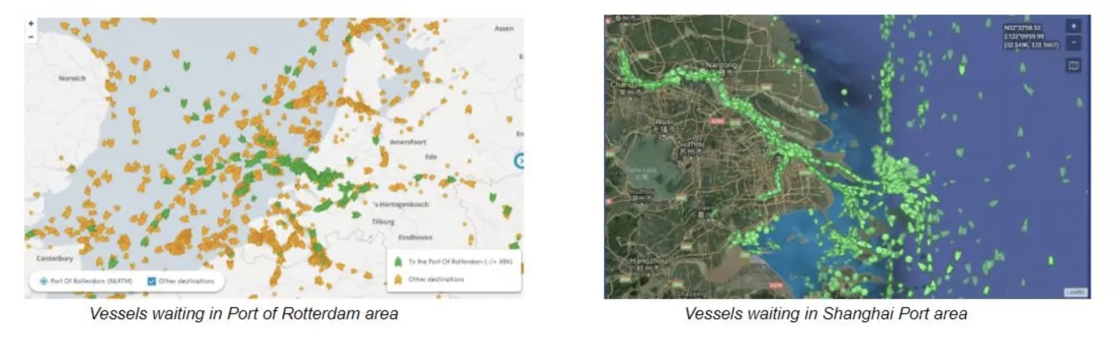
According to IHS Markit, the waiting time of ships in the port has doubled since 2019. The average number of hours spent by container ships in the port in May 2021 was raised. The average waiting time in America is 92 h, in Northern European ports – 69 h, and 40 hours in East Asia. Global waterways and maritime are more complex and less predictable. A container congestion crisis has been brewing off the coast of Southern California for many months.
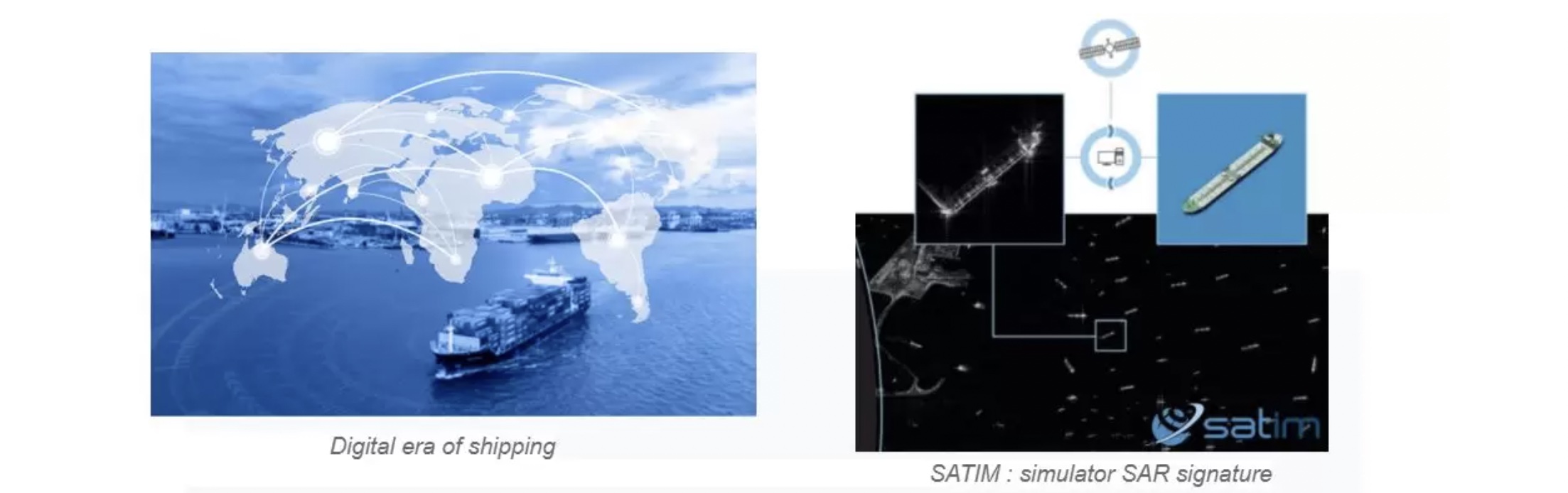
Digital era of shipping
About 20 years ago, the digital era of shipping started. Many shipowners monitor ships through AIS, RF, or VMS services, and more and more ports monitor their occupancy with the use of remote systems.
The main problem with this is that vessel detection technology was designed for vessels. The limitations, such as consciously trying to turn off them are many. It makes the general maritime awareness image extremely distorted. AIS signals can also be spotty, and the signals in ports are crowded and oftentimes interfere with each other. Moreover, in many cases, the information provided is not clear, with it often being distorted, left out, or incomplete.
How can satellite SAR-based observations support port development?
Future requirements for safe, environmentally friendly, and efficient trade operations, require new technologies in every part of the supply chain.
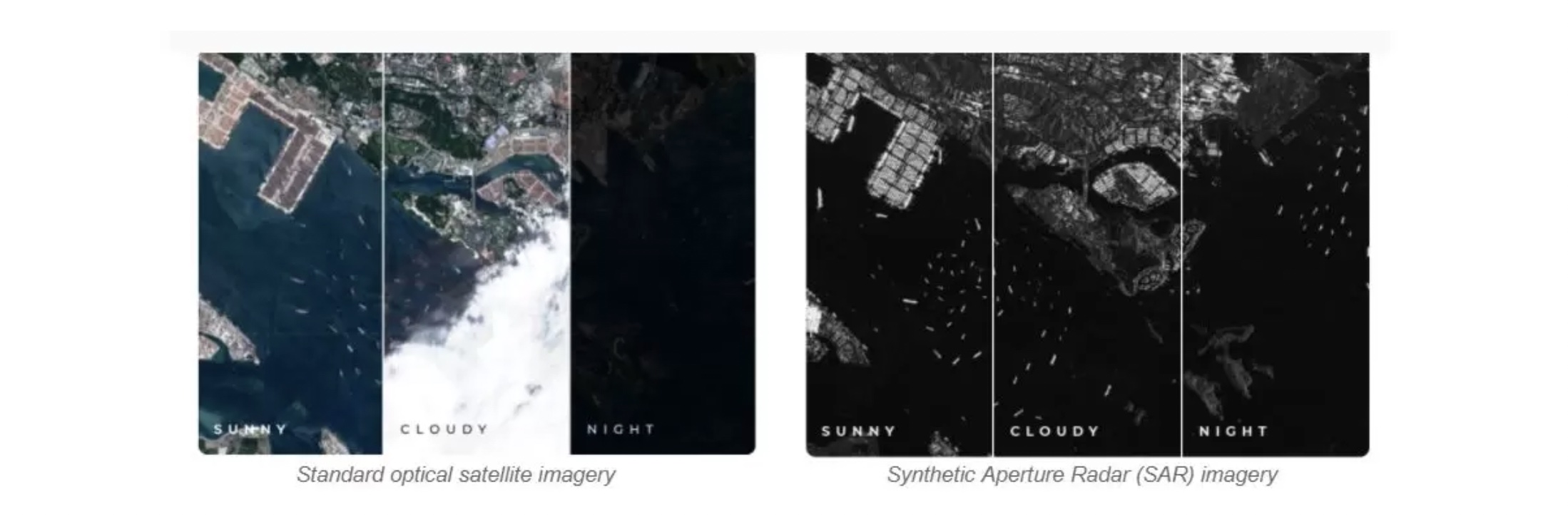
The best technology for vessel detection and port monitoring comes from satellite imagery, specifically Synthetic Aperture Radar (SAR). SAR is an all-weather and all-condition technology. It is necessary at the time of monitoring, such as the foggy or rainy season. The size of the observed area is also important. SAR images cover a much larger territorial area compared to optical ones.
Satellite data analytics are providing seaport and maritime logistic companies with innovative solutions. They can respond faster and more efficiently to major changes and unexpected situations that cause serious costs. These tools allow for controlling supply chains remotely and seeing how busy the ports are. Moreover, it can be done from anywhere and in any weather conditions. This allows port personnel to focus on other important activities that generate direct income.
You’re probably now wondering, how can you begin to take advantage of this data? Working with SAR imagery as an end-user is not easy and simple for many reasons, especially access and expertise. You need to know how to get the imagery and what to do with it. That’s our role. We make SAR easy. We are translators of complex radar-based data into actionable information and we are building solutions that directly reply to our customers’ needs. If you’re interested, email us at hello@satim.co. We’d love to have a chat.