Solutions
AI-BASED OBJECT DETECTION & ACCURATE CLASSIFICATION
SATIM are SAR experts and the world leader in object detection and classification on satellite SAR imagery. The uniqueness of our solution lies in training AI models with synthetic SAR data generated in our highly effective simulator. Using SAR signatures to train our AI model, we have the capabilities to provide near real time, accurate object detection & classification on the open sea, in port and on land.
HOW WE DO IT
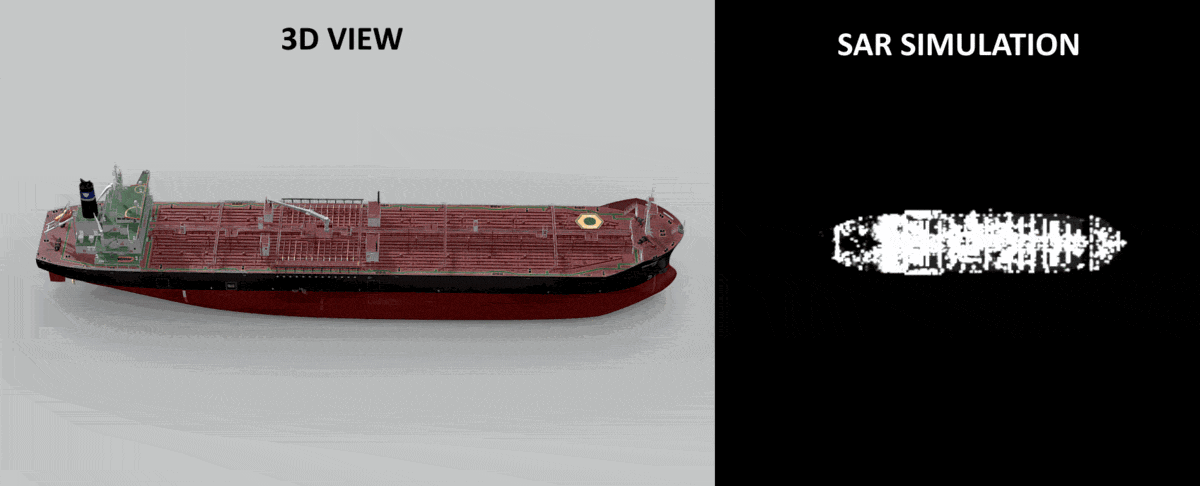
SATIM has built a highly accurate simulator for generating synthetic SAR signatures. The simulator allows us to simulate a SAR signature of any object and any SAR system. Thanks to the simulator, we can add new objects to train our AI model and to be classified within days.
Secure & Deployable Software
How it works
Developed by Satim under two contracts with ESA (over more than 6 years and tested)
BENEFITS OF OUR SOLUTION
-
HIGH ACCURACY OBJECT DETECTION & CLASSIFICATION
REAL-TIME PROCESSING FOR DECISION MAKING
NEW OBJECTS ADDED WITHIN DAYS
CIVIL & MILITARY SECTORS
RAPID INTEGRATION WITH EXISTING SYSTEMS
DEPLOYABLE, SAFE, SECURE AND RELIABLE
AIS INTEGRATION
ANY SAR SYSTEM INCLUDING AIRBORNE
ACCURATE OBJECT DETECTION & CLASSIFICATION USING SATELLITE SAR IMAGERY, ANYWHERE, ANYTIME.
What is SAR?
SAR (Synthetic Aperture Radar) is a powerful remote sensing technology bouncing microwave signals off the Earth’s surface to detect physical properties.
It is used to create high-resolution two-dimensional representations of objects.
Imagery can be captured day and night, without the usual visibility limitations of optical data and is well suited to monitoring extensive areas.
Benefits of SAR?
ALL WEATHER
DAY & NIGHT
HIGH SPATIAL RESOLUTION
HIGH TEMPORAL RESOLUTION
GLOBAL REACH
What is SAR?
SAR (Synthetic Aperture Radar) is a powerful remote sensing technology bouncing microwave signals off the Earth’s surface to detect physical properties.
It is used to create high-resolution two-dimensional representations of objects.
Imagery can be captured day and night, without the usual visibility limitations of optical data and is well suited to monitoring extensive areas.
ACCURATE OBJECT DETECTION & CLASSIFICATION USING SATELLITE SAR IMAGERY, ANYWHERE, ANYTIME.
Benefits of SAR?
ALL WEATHER
DAY & NIGHT
HIGH SPATIAL RESOLUTION
HIGH TEMPORAL RESOLUTION
GLOBAL REACH