Recently, the Intergovernmental Panel on Climate Change (IPCC) published their Sixth Assessment on Climate Change, in which they present us with some rather grave news. Climate change is here, and it’s here to stay!
How we react now will determine the direction that we will progress towards, collectively, as a society. Some of the topics covered in this report, which we really should start focusing on, are:
- Human influence is the main driver of global glacier retreat.
- An increase in the global acidification of the ocean makes it difficult for some marine species to survive.
- Human-driven Green House Gas (GHG) emissions increase the global surface temperature.
- Human-induced climate change affects many weather and climate extremes in all regions of the globe.
- The increase in global surface temperature
The five points mentioned are, probably, the most important aspects of climate change that we should consider. There are different ways to try to combat, stop, or slow down climate change. But, a tool for doing this that is not mentioned nearly enough is Earth Observation (EO). Geospatial imaging and EO are ideally fit for helping the fight against climate change because of the complementary data that they provide, the ability to see gradual changes accurately and over a long-term scale (such as melting ice & glaciers), or even simply natural resource management.

Credit: Pexels Markus Spiske
What is Earth Observation?
Well, the name itself is rather intuitive, if you ask me. EO is the process of observing the earth from above with the help of sensors or cameras. They are generally attached to a satellite or other flying/floating/freefalling object. So, pretty much anything that is up and over your head, far up in the sky, that has a camera or sensor attached to it, is an EO apparatus. But, to keep this simple, let’s stick to the idea of EO satellites.
There are really two main types of EO satellites: Synthetic Aperture Radar (SAR) and Optical. An optical satellite is a traditional satellite that produces, a regular image of the earth from space, like this (left image below).
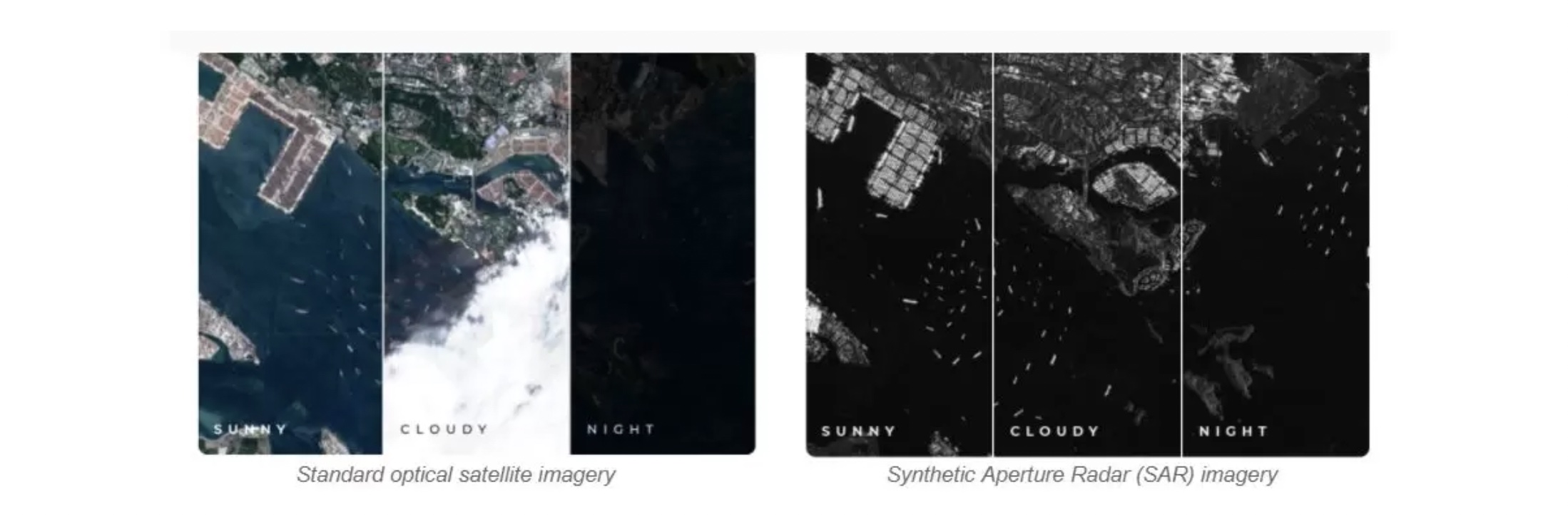
The problem with Optical satellite imagery is that it can only be utilized approximately 25% of the time. There are many factors that contribute to the ineffectiveness of Optical satellite imagery. They have limitations. Cloud cover or darkness can render these standard images incomplete or useless, leaving blindspots when monitoring.
Now, since we have the easy part out of the way, here is a SAR satellite image. Radar satellites actively send their own radio waves towards their target and then measure what is reflected. It enables them to cover large areas in a very short time. The instrument does not require sunlight. It can be used to image areas during the night and the day, and in all weather conditions (above right image). But SAR image processing is not easy and extremely difficult to interpret.
Different EO satellites are usually launched in constellations. A well-known constellation is the European Union’s Sentinel Constellation, of which there are 6 (Sentinel 1 through Sentinel 6). Each constellation is based on two satellites that fulfil the revisit and coverage requirements, which provide robust datasets for the Copernicus Services. The reason why the Sentinels are so popular is that the data that they create is free, and, let’s be honest – who doesn’t love free data? Moreover, Each mission focuses on a different aspect of Earth observation; Atmospheric, Oceanic, and Land monitoring, and the data is of use in many applications.
How can EO be used to help with the impact of climate change?
Now that you know about the satellites and Sentinels missions, let’s step back a bit and dive deeper into how EO can be used to help with or fight the impact that climate change can, and will, have on the world and global society. An increase of the global surface temperature can have many negative implications for the world. We are currently experiencing some of the early warning signs of an increased global surface temperature. There are droughts, wildfires, increased rainstorms, and, as a result, increased flooding.
To fight or counteract the effects of climate change, satellite data can and even need to be used. Satellite data provides authoritative information about more than half of the 50 crucial climate change variables.
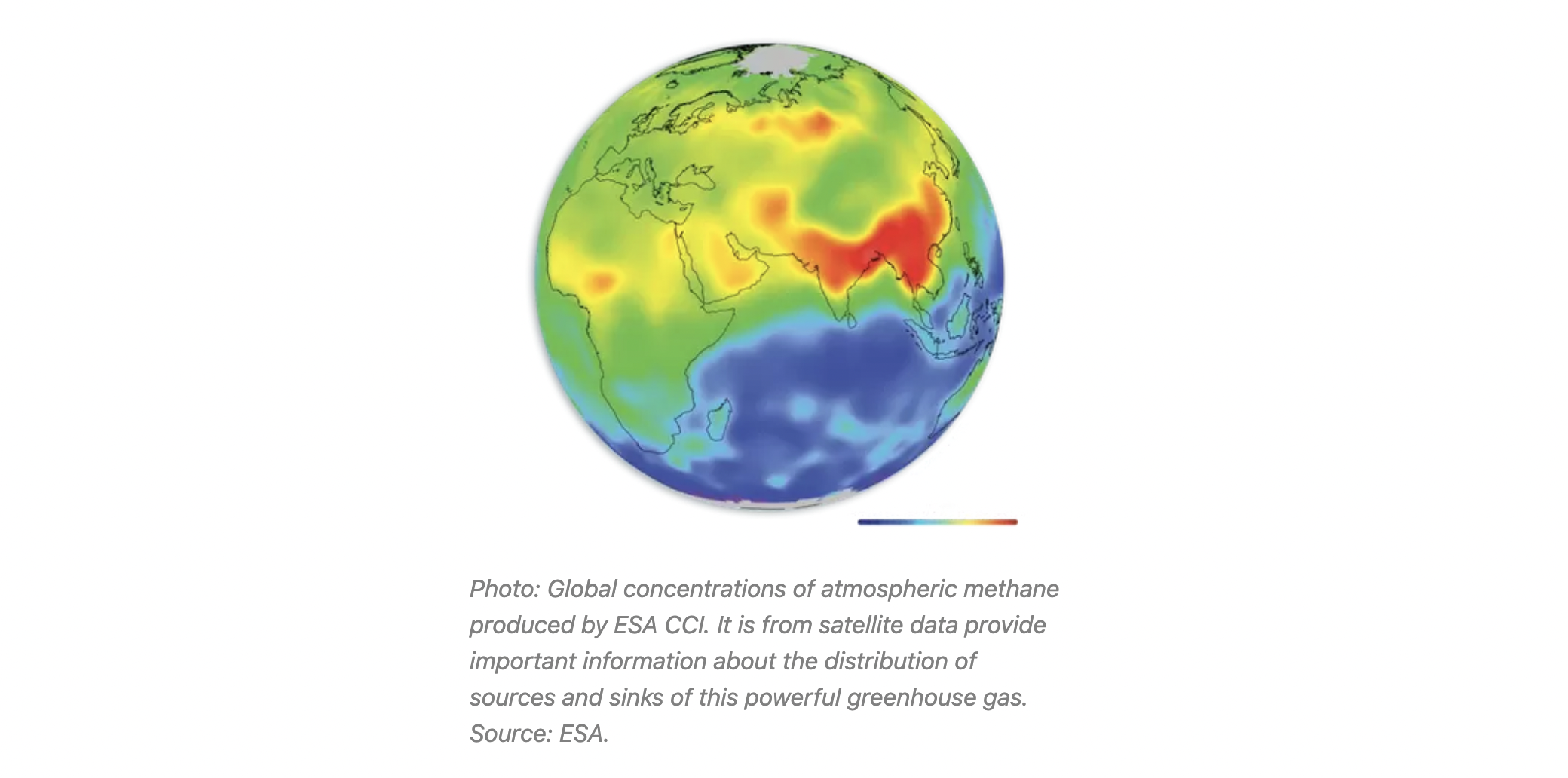
Satellite measurements of Earth’s temperature, greenhouse gas emissions, sea levels, atmospheric gases, dwindling ice, monitoring IUU fishing, ocean pollution, and forest cover, etc, are essential for improving the understanding of climate change and predicting the future of the Earth.
For example, the Sentinel-3 mission, which is mainly for applications for the ocean and coastal monitoring, numerical weather and ocean prediction, sea-level change and sea-surface topography monitoring, ocean primary production estimation and land-cover change mapping, and the Sentinel-4 mission, which is to monitor key air quality trace gases and aerosols over Europe.
The above-mentioned missions plus innovations such as the miniaturization of satellites, AI, ML, and high-speed data transfer have made satellites an integral part of the climate change mission. Earth Observation data is our “eye in the sky”. Without these inputs, decision-makers, governmental leaders, and scientists won’t be able to understand, analyze and predict the impact of climate change, and formulate effective strategies.
Within the next year, many new satellite missions will be launched (e.g. UMBRA) with enhanced image resolution and better temporal resolutions. So let’s make SAR easy and help with or fight the impact of climate change. It will be crucial if we hope to save our world. If you would like to know more about SATIM, satellite technology, or innovations in the space industry please contact us hello@satim.co